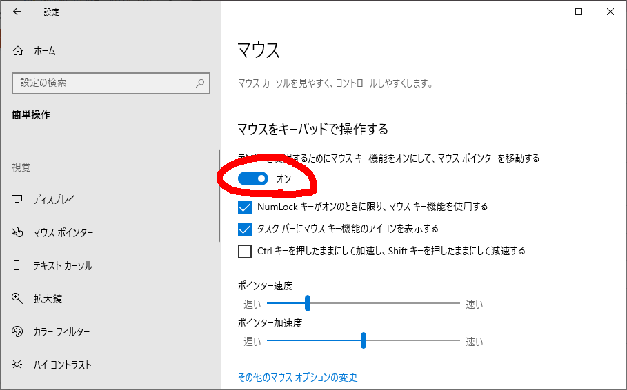
江端の環境でのローカルな場所 C:\Users\ebata\Desktop\bouncy2
C:\Users\ebata>cd C:\Users\ebata\Desktop\bouncy2
cd /c/Users/ebata/Desktop/bouncy2
python3 httpsrv.py
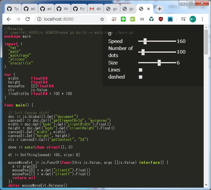
http://localhost:8080 で起動
-
2020/03/14
- 背景
- ■これからは「C/C++ → Go」と「JavaScript → Webassembly」とシフトしながら色々やっていこうと思っている■正直、どっちも難しい。そういう時は、サンプルをパクって勉強するのが正解 ―― と思っている
- 目的
- ■取り敢えず、https://github.com/stdiopt/gowasm-experiments にある、 https://stdiopt.github.io/gowasm-experiments/bouncy/ をローカルで動かせるようになろう、と考えた
- 環境
- ■Windows7 or 10
- ■Go と python3 をインストールしてある
- やってみたこと
- ■サンプルプログラムをダウンロードして、コンパイルしてみた
- ■ローカルサーバとしては、色々試してみた
- python3 -m http.server 8080
- Goでサーバも作ってみた
- Perlでもやってみた
- ■動画がどうしても出てこない
- ■ここから丸2日間の格闘のスタート
- 確認していた問題点
- ■Google Chromoから、→ 「その他のツール」 → 「ディベロッパーツール」 →
- Uncaught (in promise) TypeError: Failed to execute 'compile' on 'WebAssembly': Incorrect response MIME type. Expected 'application/wasm'.この「Expected 'application/wasm'.」がどうにも、不味いらしい ―― が、解決方法が、どうにも見つからない
- ■kobore.netのサーバに上げても、改善が見られず
- ローカルサーバを作ってみた
- ■httpsrv.pyを作った
#!/usr/bin/env python3
import http.server
  import socketserver

  PORT =
8080

  Handler = http.server.SimpleHTTPRequestHandler
  Handler.extensions_map.update({
  '.wasm': 'application/wasm',
  })

  socketserver.TCPServer.allow_reuse_address =
True
with socketserver.TCPServer(("", PORT), Handler) as httpd:
  httpd.allow_reuse_address =
True
print("serving at port", PORT)
  httpd.serve_forever()
- ■httpsrv.pyを起動した
- http://localhost:8080 で起動
- ■動いた
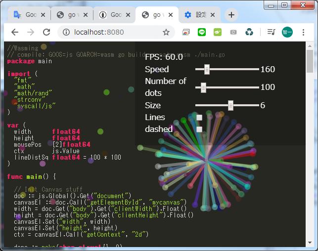
■動かなかったら、chromo → 「設定」 → 「閲覧履歴データの削除」でキャッシュをクリアてみること
以上
httpsrv.py
#!/usr/bin/env python3

import http.server
import socketserver

PORT = 8080

Handler = http.server.SimpleHTTPRequestHandler
Handler.extensions_map.update({
    '.wasm': 'application/wasm',
})

socketserver.TCPServer.allow_reuse_address = True
with socketserver.TCPServer(("", PORT), Handler) as httpd:
    httpd.allow_reuse_address = True
    print("serving at port", PORT)
    httpd.serve_forever()
main.go
//Wasming
// compile: GOOS=js GOARCH=wasm go build -o main.wasm ./main.go
package main

import (
	"fmt"
	"math"
	"math/rand"
	"strconv"
	"syscall/js"
)

var (
	width      float64
	height     float64
	mousePos   [2]float64
	ctx        js.Value    // "syscall/js"から引っ張られる
	lineDistSq float64 = 100 * 100
)

func main() {

	// Init Canvas stuff
	doc := js.Global().Get("document")
	canvasEl := doc.Call("getElementById", "mycanvas")
	width = doc.Get("body").Get("clientWidth").Float()
	height = doc.Get("body").Get("clientHeight").Float()
	canvasEl.Set("width", width)
	canvasEl.Set("height", height)
	ctx = canvasEl.Call("getContext", "2d")

	done := make(chan struct{}, 0)

	dt := DotThing{speed: 160, size: 6}

	mouseMoveEvt := js.FuncOf(func(this js.Value, args []js.Value) interface{} {
		e := args[0]
		mousePos[0] = e.Get("clientX").Float()
		mousePos[1] = e.Get("clientY").Float()
		return nil
	})
	defer mouseMoveEvt.Release()

	// Event handler for count range
	countChangeEvt := js.FuncOf(func(this js.Value, args []js.Value) interface{} {
		evt := args[0]
		intVal, err := strconv.Atoi(evt.Get("target").Get("value").String())
		if err != nil {
			println("Invalid value", err)
			return nil
		}
		dt.SetNDots(intVal)
		return nil
	})
	defer countChangeEvt.Release()

	// Event handler for speed range
	speedInputEvt := js.FuncOf(func(this js.Value, args []js.Value) interface{} {
		evt := args[0]
		fval, err := strconv.ParseFloat(evt.Get("target").Get("value").String(), 64)
		if err != nil {
			println("invalid value", err)
			return nil
		}
		dt.speed = fval
		return nil
	})
	defer speedInputEvt.Release()

	// Event handler for size
	sizeChangeEvt := js.FuncOf(func(this js.Value, args []js.Value) interface{} {
		evt := args[0]
		intVal, err := strconv.Atoi(evt.Get("target").Get("value").String())
		if err != nil {
			println("invalid value", err)
			return nil
		}
		dt.size = intVal
		return nil
	})
	defer sizeChangeEvt.Release()

	// Event handler for lines toggle
	lineChangeEvt := js.FuncOf(func(this js.Value, args []js.Value) interface{} {
		evt := args[0]
		dt.lines = evt.Get("target").Get("checked").Bool()
		return nil
	})
	defer lineChangeEvt.Release()

	// Event handler for dashed toggle
	dashedChangeEvt := js.FuncOf(func(this js.Value, args []js.Value) interface{} {
		evt := args[0]
		dt.dashed = evt.Get("target").Get("checked").Bool()
		return nil
	})
	defer dashedChangeEvt.Release()

	doc.Call("addEventListener", "mousemove", mouseMoveEvt)
	doc.Call("getElementById", "count").Call("addEventListener", "change", countChangeEvt)
	doc.Call("getElementById", "speed").Call("addEventListener", "input", speedInputEvt)
	doc.Call("getElementById", "size").Call("addEventListener", "input", sizeChangeEvt)
	doc.Call("getElementById", "dashed").Call("addEventListener", "change", dashedChangeEvt)
	doc.Call("getElementById", "lines").Call("addEventListener", "change", lineChangeEvt)

	dt.SetNDots(100)
	dt.lines = false
	var renderFrame js.Func
	var tmark float64
	var markCount = 0
	var tdiffSum float64

	renderFrame = js.FuncOf(func(this js.Value, args []js.Value) interface{} {
		now := args[0].Float()
		tdiff := now - tmark
		tdiffSum += now - tmark
		markCount++
		if markCount > 10 {
			doc.Call("getElementById", "fps").Set("innerHTML", fmt.Sprintf("FPS: %.01f", 1000/(tdiffSum/float64(markCount))))
			tdiffSum, markCount = 0, 0
		}
		tmark = now

		// Pull window size to handle resize
		curBodyW := doc.Get("body").Get("clientWidth").Float()
		curBodyH := doc.Get("body").Get("clientHeight").Float()
		if curBodyW != width || curBodyH != height {
			width, height = curBodyW, curBodyH
			canvasEl.Set("width", width)
			canvasEl.Set("height", height)
		}
		dt.Update(tdiff / 1000)

		js.Global().Call("requestAnimationFrame", renderFrame)
		return nil
	})
	defer renderFrame.Release()

	// Start running
	js.Global().Call("requestAnimationFrame", renderFrame)

	<-done

}

// DotThing manager
type DotThing struct {
	dots   []*Dot
	dashed bool
	lines  bool
	speed  float64
	size   int
}

// Update updates the dot positions and draws
func (dt *DotThing) Update(dtTime float64) {
	if dt.dots == nil {
		return
	}
	ctx.Call("clearRect", 0, 0, width, height)

	// Update
	for i, dot := range dt.dots {
		dir := [2]float64{}
		// Bounce
		if dot.pos[0] < 0 {
			dot.pos[0] = 0
			dot.dir[0] *= -1
		}
		if dot.pos[0] > width {
			dot.pos[0] = width
			dot.dir[0] *= -1
		}

		if dot.pos[1] < 0 {
			dot.pos[1] = 0
			dot.dir[1] *= -1
		}

		if dot.pos[1] > height {
			dot.pos[1] = height
			dot.dir[1] *= -1
		}
		dir = dot.dir

		ctx.Set("globalAlpha", 0.5)
		ctx.Call("beginPath")
		ctx.Set("fillStyle", fmt.Sprintf("#%06x", dot.color))
		ctx.Set("strokeStyle", fmt.Sprintf("#%06x", dot.color))
		// Dashed array ref: https://github.com/golang/go/blob/release-branch.go1.11/src/syscall/js/js.go#L98
		ctx.Call("setLineDash", []interface{}{})
		if dt.dashed {
			ctx.Call("setLineDash", []interface{}{5, 10})
		}
		ctx.Set("lineWidth", dt.size)
		ctx.Call("arc", dot.pos[0], dot.pos[1], dt.size, 0, 2*math.Pi)
		ctx.Call("fill")

		mdx := mousePos[0] - dot.pos[0]
		mdy := mousePos[1] - dot.pos[1]
		d := math.Sqrt(mdx*mdx + mdy*mdy)
		if d < 200 {
			ctx.Set("globalAlpha", 1-d/200)
			ctx.Call("beginPath")
			ctx.Call("moveTo", dot.pos[0], dot.pos[1])
			ctx.Call("lineTo", mousePos[0], mousePos[1])
			ctx.Call("stroke")
			if d > 100 { // move towards mouse
				dir[0] = (mdx / d) * 2
				dir[1] = (mdy / d) * 2
			} else { // do not move
				dir[0] = 0
				dir[1] = 0
			}
		}

		if dt.lines {
			for _, dot2 := range dt.dots[i+1:] {
				mx := dot2.pos[0] - dot.pos[0]
				my := dot2.pos[1] - dot.pos[1]
				d := mx*mx + my*my
				if d < lineDistSq {
					ctx.Set("globalAlpha", 1-d/lineDistSq)
					ctx.Call("beginPath")
					ctx.Call("moveTo", dot.pos[0], dot.pos[1])
					ctx.Call("lineTo", dot2.pos[0], dot2.pos[1])
					ctx.Call("stroke")
				}
			}
		}

		dot.pos[0] += dir[0] * dt.speed * dtTime
		dot.pos[1] += dir[1] * dt.speed * dtTime
	}
}

// SetNDots reinitializes dots with n size
func (dt *DotThing) SetNDots(n int) {
	dt.dots = make([]*Dot, n)
	for i := 0; i < n; i++ {
		dt.dots[i] = &Dot{
			pos: [2]float64{
				rand.Float64() * width,
				rand.Float64() * height,
			},
			dir: [2]float64{
				rand.NormFloat64(),
				rand.NormFloat64(),
			},
			color: uint32(rand.Intn(0xFFFFFF)),
			size:  10,
		}
	}
}

// Dot represents a dot ...
type Dot struct {
	pos   [2]float64
	dir   [2]float64
	color uint32
	size  float64
}
build.sh
#!/bin/sh

GOOS=js GOARCH=wasm go build -o main.wasm ./main.go
wasm_exec.js
// Copyright 2018 The Go Authors. All rights reserved.
// Use of this source code is governed by a BSD-style
// license that can be found in the LICENSE file.

(() => {
	// Map multiple JavaScript environments to a single common API,
	// preferring web standards over Node.js API.
	//
	// Environments considered:
	// - Browsers
	// - Node.js
	// - Electron
	// - Parcel

	if (typeof global !== "undefined") {
		// global already exists
	} else if (typeof window !== "undefined") {
		window.global = window;
	} else if (typeof self !== "undefined") {
		self.global = self;
	} else {
		throw new Error("cannot export Go (neither global, window nor self is defined)");
	}

	if (!global.require && typeof require !== "undefined") {
		global.require = require;
	}

	if (!global.fs && global.require) {
		global.fs = require("fs");
	}

	const enosys = () => {
		const err = new Error("not implemented");
		err.code = "ENOSYS";
		return err;
	};

	if (!global.fs) {
		let outputBuf = "";
		global.fs = {
			constants: { O_WRONLY: -1, O_RDWR: -1, O_CREAT: -1, O_TRUNC: -1, O_APPEND: -1, O_EXCL: -1 }, // unused
			writeSync(fd, buf) {
				outputBuf += decoder.decode(buf);
				const nl = outputBuf.lastIndexOf("\n");
				if (nl != -1) {
					console.log(outputBuf.substr(0, nl));
					outputBuf = outputBuf.substr(nl + 1);
				}
				return buf.length;
			},
			write(fd, buf, offset, length, position, callback) {
				if (offset !== 0 || length !== buf.length || position !== null) {
					callback(enosys());
					return;
				}
				const n = this.writeSync(fd, buf);
				callback(null, n);
			},
			chmod(path, mode, callback) { callback(enosys()); },
			chown(path, uid, gid, callback) { callback(enosys()); },
			close(fd, callback) { callback(enosys()); },
			fchmod(fd, mode, callback) { callback(enosys()); },
			fchown(fd, uid, gid, callback) { callback(enosys()); },
			fstat(fd, callback) { callback(enosys()); },
			fsync(fd, callback) { callback(null); },
			ftruncate(fd, length, callback) { callback(enosys()); },
			lchown(path, uid, gid, callback) { callback(enosys()); },
			link(path, link, callback) { callback(enosys()); },
			lstat(path, callback) { callback(enosys()); },
			mkdir(path, perm, callback) { callback(enosys()); },
			open(path, flags, mode, callback) { callback(enosys()); },
			read(fd, buffer, offset, length, position, callback) { callback(enosys()); },
			readdir(path, callback) { callback(enosys()); },
			readlink(path, callback) { callback(enosys()); },
			rename(from, to, callback) { callback(enosys()); },
			rmdir(path, callback) { callback(enosys()); },
			stat(path, callback) { callback(enosys()); },
			symlink(path, link, callback) { callback(enosys()); },
			truncate(path, length, callback) { callback(enosys()); },
			unlink(path, callback) { callback(enosys()); },
			utimes(path, atime, mtime, callback) { callback(enosys()); },
		};
	}

	if (!global.process) {
		global.process = {
			getuid() { return -1; },
			getgid() { return -1; },
			geteuid() { return -1; },
			getegid() { return -1; },
			getgroups() { throw enosys(); },
			pid: -1,
			ppid: -1,
			umask() { throw enosys(); },
			cwd() { throw enosys(); },
			chdir() { throw enosys(); },
		}
	}

	if (!global.crypto) {
		const nodeCrypto = require("crypto");
		global.crypto = {
			getRandomValues(b) {
				nodeCrypto.randomFillSync(b);
			},
		};
	}

	if (!global.performance) {
		global.performance = {
			now() {
				const [sec, nsec] = process.hrtime();
				return sec * 1000 + nsec / 1000000;
			},
		};
	}

	if (!global.TextEncoder) {
		global.TextEncoder = require("util").TextEncoder;
	}

	if (!global.TextDecoder) {
		global.TextDecoder = require("util").TextDecoder;
	}

	// End of polyfills for common API.

	const encoder = new TextEncoder("utf-8");
	const decoder = new TextDecoder("utf-8");

	global.Go = class {
		constructor() {
			this.argv = ["js"];
			this.env = {};
			this.exit = (code) => {
				if (code !== 0) {
					console.warn("exit code:", code);
				}
			};
			this._exitPromise = new Promise((resolve) => {
				this._resolveExitPromise = resolve;
			});
			this._pendingEvent = null;
			this._scheduledTimeouts = new Map();
			this._nextCallbackTimeoutID = 1;

			const setInt64 = (addr, v) => {
				this.mem.setUint32(addr + 0, v, true);
				this.mem.setUint32(addr + 4, Math.floor(v / 4294967296), true);
			}

			const getInt64 = (addr) => {
				const low = this.mem.getUint32(addr + 0, true);
				const high = this.mem.getInt32(addr + 4, true);
				return low + high * 4294967296;
			}

			const loadValue = (addr) => {
				const f = this.mem.getFloat64(addr, true);
				if (f === 0) {
					return undefined;
				}
				if (!isNaN(f)) {
					return f;
				}

				const id = this.mem.getUint32(addr, true);
				return this._values[id];
			}

			const storeValue = (addr, v) => {
				const nanHead = 0x7FF80000;

				if (typeof v === "number") {
					if (isNaN(v)) {
						this.mem.setUint32(addr + 4, nanHead, true);
						this.mem.setUint32(addr, 0, true);
						return;
					}
					if (v === 0) {
						this.mem.setUint32(addr + 4, nanHead, true);
						this.mem.setUint32(addr, 1, true);
						return;
					}
					this.mem.setFloat64(addr, v, true);
					return;
				}

				switch (v) {
					case undefined:
						this.mem.setFloat64(addr, 0, true);
						return;
					case null:
						this.mem.setUint32(addr + 4, nanHead, true);
						this.mem.setUint32(addr, 2, true);
						return;
					case true:
						this.mem.setUint32(addr + 4, nanHead, true);
						this.mem.setUint32(addr, 3, true);
						return;
					case false:
						this.mem.setUint32(addr + 4, nanHead, true);
						this.mem.setUint32(addr, 4, true);
						return;
				}

				let id = this._ids.get(v);
				if (id === undefined) {
					id = this._idPool.pop();
					if (id === undefined) {
						id = this._values.length;
					}
					this._values[id] = v;
					this._goRefCounts[id] = 0;
					this._ids.set(v, id);
				}
				this._goRefCounts[id]++;
				let typeFlag = 1;
				switch (typeof v) {
					case "string":
						typeFlag = 2;
						break;
					case "symbol":
						typeFlag = 3;
						break;
					case "function":
						typeFlag = 4;
						break;
				}
				this.mem.setUint32(addr + 4, nanHead | typeFlag, true);
				this.mem.setUint32(addr, id, true);
			}

			const loadSlice = (addr) => {
				const array = getInt64(addr + 0);
				const len = getInt64(addr + 8);
				return new Uint8Array(this._inst.exports.mem.buffer, array, len);
			}

			const loadSliceOfValues = (addr) => {
				const array = getInt64(addr + 0);
				const len = getInt64(addr + 8);
				const a = new Array(len);
				for (let i = 0; i < len; i++) {
					a[i] = loadValue(array + i * 8);
				}
				return a;
			}

			const loadString = (addr) => {
				const saddr = getInt64(addr + 0);
				const len = getInt64(addr + 8);
				return decoder.decode(new DataView(this._inst.exports.mem.buffer, saddr, len));
			}

			const timeOrigin = Date.now() - performance.now();
			this.importObject = {
				go: {
					// Go's SP does not change as long as no Go code is running. Some operations (e.g. calls, getters and setters)
					// may synchronously trigger a Go event handler. This makes Go code get executed in the middle of the imported
					// function. A goroutine can switch to a new stack if the current stack is too small (see morestack function).
					// This changes the SP, thus we have to update the SP used by the imported function.

					// func wasmExit(code int32)
					"runtime.wasmExit": (sp) => {
						const code = this.mem.getInt32(sp + 8, true);
						this.exited = true;
						delete this._inst;
						delete this._values;
						delete this._goRefCounts;
						delete this._ids;
						delete this._idPool;
						this.exit(code);
					},

					// func wasmWrite(fd uintptr, p unsafe.Pointer, n int32)
					"runtime.wasmWrite": (sp) => {
						const fd = getInt64(sp + 8);
						const p = getInt64(sp + 16);
						const n = this.mem.getInt32(sp + 24, true);
						fs.writeSync(fd, new Uint8Array(this._inst.exports.mem.buffer, p, n));
					},

					// func resetMemoryDataView()
					"runtime.resetMemoryDataView": (sp) => {
						this.mem = new DataView(this._inst.exports.mem.buffer);
					},

					// func nanotime1() int64
					"runtime.nanotime1": (sp) => {
						setInt64(sp + 8, (timeOrigin + performance.now()) * 1000000);
					},

					// func walltime1() (sec int64, nsec int32)
					"runtime.walltime1": (sp) => {
						const msec = (new Date).getTime();
						setInt64(sp + 8, msec / 1000);
						this.mem.setInt32(sp + 16, (msec % 1000) * 1000000, true);
					},

					// func scheduleTimeoutEvent(delay int64) int32
					"runtime.scheduleTimeoutEvent": (sp) => {
						const id = this._nextCallbackTimeoutID;
						this._nextCallbackTimeoutID++;
						this._scheduledTimeouts.set(id, setTimeout(
							() => {
								this._resume();
								while (this._scheduledTimeouts.has(id)) {
									// for some reason Go failed to register the timeout event, log and try again
									// (temporary workaround for https://github.com/golang/go/issues/28975)
									console.warn("scheduleTimeoutEvent: missed timeout event");
									this._resume();
								}
							},
							getInt64(sp + 8) + 1, // setTimeout has been seen to fire up to 1 millisecond early
						));
						this.mem.setInt32(sp + 16, id, true);
					},

					// func clearTimeoutEvent(id int32)
					"runtime.clearTimeoutEvent": (sp) => {
						const id = this.mem.getInt32(sp + 8, true);
						clearTimeout(this._scheduledTimeouts.get(id));
						this._scheduledTimeouts.delete(id);
					},

					// func getRandomData(r []byte)
					"runtime.getRandomData": (sp) => {
						crypto.getRandomValues(loadSlice(sp + 8));
					},

					// func finalizeRef(v ref)
					"syscall/js.finalizeRef": (sp) => {
						const id = this.mem.getUint32(sp + 8, true);
						this._goRefCounts[id]--;
						if (this._goRefCounts[id] === 0) {
							const v = this._values[id];
							this._values[id] = null;
							this._ids.delete(v);
							this._idPool.push(id);
						}
					},

					// func stringVal(value string) ref
					"syscall/js.stringVal": (sp) => {
						storeValue(sp + 24, loadString(sp + 8));
					},

					// func valueGet(v ref, p string) ref
					"syscall/js.valueGet": (sp) => {
						const result = Reflect.get(loadValue(sp + 8), loadString(sp + 16));
						sp = this._inst.exports.getsp(); // see comment above
						storeValue(sp + 32, result);
					},

					// func valueSet(v ref, p string, x ref)
					"syscall/js.valueSet": (sp) => {
						Reflect.set(loadValue(sp + 8), loadString(sp + 16), loadValue(sp + 32));
					},

					// func valueDelete(v ref, p string)
					"syscall/js.valueDelete": (sp) => {
						Reflect.deleteProperty(loadValue(sp + 8), loadString(sp + 16));
					},

					// func valueIndex(v ref, i int) ref
					"syscall/js.valueIndex": (sp) => {
						storeValue(sp + 24, Reflect.get(loadValue(sp + 8), getInt64(sp + 16)));
					},

					// valueSetIndex(v ref, i int, x ref)
					"syscall/js.valueSetIndex": (sp) => {
						Reflect.set(loadValue(sp + 8), getInt64(sp + 16), loadValue(sp + 24));
					},

					// func valueCall(v ref, m string, args []ref) (ref, bool)
					"syscall/js.valueCall": (sp) => {
						try {
							const v = loadValue(sp + 8);
							const m = Reflect.get(v, loadString(sp + 16));
							const args = loadSliceOfValues(sp + 32);
							const result = Reflect.apply(m, v, args);
							sp = this._inst.exports.getsp(); // see comment above
							storeValue(sp + 56, result);
							this.mem.setUint8(sp + 64, 1);
						} catch (err) {
							storeValue(sp + 56, err);
							this.mem.setUint8(sp + 64, 0);
						}
					},

					// func valueInvoke(v ref, args []ref) (ref, bool)
					"syscall/js.valueInvoke": (sp) => {
						try {
							const v = loadValue(sp + 8);
							const args = loadSliceOfValues(sp + 16);
							const result = Reflect.apply(v, undefined, args);
							sp = this._inst.exports.getsp(); // see comment above
							storeValue(sp + 40, result);
							this.mem.setUint8(sp + 48, 1);
						} catch (err) {
							storeValue(sp + 40, err);
							this.mem.setUint8(sp + 48, 0);
						}
					},

					// func valueNew(v ref, args []ref) (ref, bool)
					"syscall/js.valueNew": (sp) => {
						try {
							const v = loadValue(sp + 8);
							const args = loadSliceOfValues(sp + 16);
							const result = Reflect.construct(v, args);
							sp = this._inst.exports.getsp(); // see comment above
							storeValue(sp + 40, result);
							this.mem.setUint8(sp + 48, 1);
						} catch (err) {
							storeValue(sp + 40, err);
							this.mem.setUint8(sp + 48, 0);
						}
					},

					// func valueLength(v ref) int
					"syscall/js.valueLength": (sp) => {
						setInt64(sp + 16, parseInt(loadValue(sp + 8).length));
					},

					// valuePrepareString(v ref) (ref, int)
					"syscall/js.valuePrepareString": (sp) => {
						const str = encoder.encode(String(loadValue(sp + 8)));
						storeValue(sp + 16, str);
						setInt64(sp + 24, str.length);
					},

					// valueLoadString(v ref, b []byte)
					"syscall/js.valueLoadString": (sp) => {
						const str = loadValue(sp + 8);
						loadSlice(sp + 16).set(str);
					},

					// func valueInstanceOf(v ref, t ref) bool
					"syscall/js.valueInstanceOf": (sp) => {
						this.mem.setUint8(sp + 24, loadValue(sp + 8) instanceof loadValue(sp + 16));
					},

					// func copyBytesToGo(dst []byte, src ref) (int, bool)
					"syscall/js.copyBytesToGo": (sp) => {
						const dst = loadSlice(sp + 8);
						const src = loadValue(sp + 32);
						if (!(src instanceof Uint8Array)) {
							this.mem.setUint8(sp + 48, 0);
							return;
						}
						const toCopy = src.subarray(0, dst.length);
						dst.set(toCopy);
						setInt64(sp + 40, toCopy.length);
						this.mem.setUint8(sp + 48, 1);
					},

					// func copyBytesToJS(dst ref, src []byte) (int, bool)
					"syscall/js.copyBytesToJS": (sp) => {
						const dst = loadValue(sp + 8);
						const src = loadSlice(sp + 16);
						if (!(dst instanceof Uint8Array)) {
							this.mem.setUint8(sp + 48, 0);
							return;
						}
						const toCopy = src.subarray(0, dst.length);
						dst.set(toCopy);
						setInt64(sp + 40, toCopy.length);
						this.mem.setUint8(sp + 48, 1);
					},

					"debug": (value) => {
						console.log(value);
					},
				}
			};
		}

		async run(instance) {
			this._inst = instance;
			this.mem = new DataView(this._inst.exports.mem.buffer);
			this._values = [ // JS values that Go currently has references to, indexed by reference id
				NaN,
				0,
				null,
				true,
				false,
				global,
				this,
			];
			this._goRefCounts = []; // number of references that Go has to a JS value, indexed by reference id
			this._ids = new Map();  // mapping from JS values to reference ids
			this._idPool = [];      // unused ids that have been garbage collected
			this.exited = false;    // whether the Go program has exited

			// Pass command line arguments and environment variables to WebAssembly by writing them to the linear memory.
			let offset = 4096;

			const strPtr = (str) => {
				const ptr = offset;
				const bytes = encoder.encode(str + "\0");
				new Uint8Array(this.mem.buffer, offset, bytes.length).set(bytes);
				offset += bytes.length;
				if (offset % 8 !== 0) {
					offset += 8 - (offset % 8);
				}
				return ptr;
			};

			const argc = this.argv.length;

			const argvPtrs = [];
			this.argv.forEach((arg) => {
				argvPtrs.push(strPtr(arg));
			});
			argvPtrs.push(0);

			const keys = Object.keys(this.env).sort();
			keys.forEach((key) => {
				argvPtrs.push(strPtr(`${key}=${this.env[key]}`));
			});
			argvPtrs.push(0);

			const argv = offset;
			argvPtrs.forEach((ptr) => {
				this.mem.setUint32(offset, ptr, true);
				this.mem.setUint32(offset + 4, 0, true);
				offset += 8;
			});

			this._inst.exports.run(argc, argv);
			if (this.exited) {
				this._resolveExitPromise();
			}
			await this._exitPromise;
		}

		_resume() {
			if (this.exited) {
				throw new Error("Go program has already exited");
			}
			this._inst.exports.resume();
			if (this.exited) {
				this._resolveExitPromise();
			}
		}

		_makeFuncWrapper(id) {
			const go = this;
			return function () {
				const event = { id: id, this: this, args: arguments };
				go._pendingEvent = event;
				go._resume();
				return event.result;
			};
		}
	}

	if (
		global.require &&
		global.require.main === module &&
		global.process &&
		global.process.versions &&
		!global.process.versions.electron
	) {
		if (process.argv.length < 3) {
			console.error("usage: go_js_wasm_exec [wasm binary] [arguments]");
			process.exit(1);
		}

		const go = new Go();
		go.argv = process.argv.slice(2);
		go.env = Object.assign({ TMPDIR: require("os").tmpdir() }, process.env);
		go.exit = process.exit;
		WebAssembly.instantiate(fs.readFileSync(process.argv[2]), go.importObject).then((result) => {
			process.on("exit", (code) => { // Node.js exits if no event handler is pending
				if (code === 0 && !go.exited) {
					// deadlock, make Go print error and stack traces
					go._pendingEvent = { id: 0 };
					go._resume();
				}
			});
			return go.run(result.instance);
		}).catch((err) => {
			console.error(err);
			process.exit(1);
		});
	}
})();
