なんでもかんでも、ニューラルネットワークに突っ込む必要はないと思うんですよね。
/*
c:\users\ebata\tomioka3b\src\others\main41.go
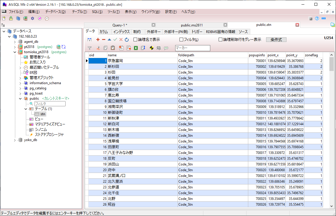
このプログラムは、与えられた地点の緯度経度情報と京急富岡駅からの電車による移動時間を元に、スプライン補間を行い、特定の座標における移動時間を補間することを目的としています。
Point 構造体は、地点の名前 (Name)、緯度 (Latitude)、経度 (Longitude)、移動時間 (min2Tomioka) の情報を保持します。
convertToDataSet 関数は、Point 構造体の配列を受け取り、それを緯度、経度、標高の情報を含む二次元配列データセットに変換します。
splineInterpolation 関数は、スプライン補間を行うための関数を返します。この関数は、与えられたデータセットを元に、スプライン補間に必要な計算を行います。
main 関数では、与えられた地点の情報を元に Point 構造体のスライスが定義され、それを convertToDataSet 関数で二次元配列データセットに変換します。
さらに、splineInterpolation 関数を使用してスプライン補間関数を生成し、特定の座標における移動時間を補間します。
最後に、補間された値が出力されます。
このプログラムは、地理空間データの補間処理に利用できる汎用的なスプライン補間関数を提供します。
*/
package main
import (
"fmt"
"sort"
)
type Point struct {
Name string
Latitude float64
Longitude float64
min2Tomioka float64
}
// スプライン補間用の関数
func splineInterpolation(dataSet [][]float64) func(float64, float64) float64 {
n := len(dataSet)
// xの値を昇順にソートする
sort.Slice(dataSet, func(i, j int) bool {
return dataSet[i][0] < dataSet[j][0]
})
// トリディアゴナル行列を作成
h := make([]float64, n-1)
for i := 0; i < n-1; i++ {
h[i] = dataSet[i+1][0] - dataSet[i][0]
}
// 2階微分の値を計算
delta := make([]float64, n)
for i := 1; i < n-1; i++ {
delta[i] = (dataSet[i+1][1]-dataSet[i][1])/h[i] - (dataSet[i][1]-dataSet[i-1][1])/h[i-1]
}
// トリディアゴナル行列を解く
m := make([]float64, n)
l := make([]float64, n)
zArray := make([]float64, n)
l[0] = 1
for i := 1; i < n-1; i++ {
l[i] = 2*(dataSet[i+1][0]-dataSet[i-1][0]) - h[i-1]*m[i-1]
m[i] = h[i] / l[i]
zArray[i] = (delta[i] - h[i-1]*zArray[i-1]) / l[i]
}
l[n-1] = 1
zArray[n-1] = 0
c := make([]float64, n)
b := make([]float64, n)
d := make([]float64, n)
for j := n - 2; j >= 0; j-- {
c[j] = zArray[j] - m[j]*c[j+1]
b[j] = (dataSet[j+1][1]-dataSet[j][1])/h[j] - h[j]*(c[j+1]+2*c[j])/3
d[j] = (c[j+1] - c[j]) / (3 * h[j])
}
// 補間関数を返す
return func(xVal, yVal float64) float64 {
// xの範囲を確認
if xVal < dataSet[0][0] || xVal > dataSet[n-1][0] {
panic("x value is out of range")
}
// 対応するiを探す
i := 0
for i < n-1 && dataSet[i+1][0] <= xVal {
i++
}
// スプライン補間を計算
dx := xVal - dataSet[i][0]
return dataSet[i][2] + b[i]*dx + c[i]*dx*dx + d[i]*dx*dx*dx
}
}
func convertToDataSet(points []Point) [][]float64 {
var dataSet [][]float64
for _, point := range points {
data := []float64{point.Latitude, point.Longitude, point.min2Tomioka}
dataSet = append(dataSet, data)
}
return dataSet
}
func main() {
points := []Point{
{"日暮里", 35.72810551475649, 139.77065214505967, 73}, // 日暮里
{"鶯谷", 35.72147285483459, 139.77803484630024, 63}, // 鶯谷
{"上野", 35.71419330617392, 139.7774413019538, 57}, // 上野
{"御徒町", 35.70752513412557, 139.7748544863164, 67}, // 御徒町
{"秋葉原", 35.6983999333567, 139.77290571388025, 65}, // 秋葉原
{"お茶の水", 35.69977763102643, 139.76447338219248, 61}, // お茶の水
{"水道橋", 35.7020483726974, 139.75337286940393, 66}, // 水道橋
{"神田", 35.691843953947895, 139.77075286750426, 63}, // 神田
{"東京", 35.68127103173912, 139.76691023873528, 57}, // 東京
{"有楽町", 35.67504451109795, 139.7629009441794, 59}, // 有楽町
{"新橋", 35.6663876890884, 139.7580715945385, 55}, // 新橋
{"浜松町", 35.65538959029243, 139.75707527127187, 54}, // 浜松町
{"田町", 35.64573607270807, 139.7475731442898, 54}, // 田町
{"品川", 35.628479993237924, 139.73869534241823, 43}, // 品川
{"北品川", 35.62204337901307, 139.73929378869565, 50}, // 北品川
{"青物横丁", 35.616530476669595, 139.74147241132803, 49}, // 新馬場
{"青物横丁", 35.6089113073848, 139.74314516357873, 45}, // 青物横丁
{"鮫洲", 35.60505014227371, 139.74226998316405, 50}, // 鮫洲
{"立会川", 35.598565208786674, 139.73893538884946, 50}, // 立会川
{"大森海岸", 35.58770513004266, 139.73546417819148, 51}, // 大森海岸
{"平和島", 35.578786612348516, 139.7348957122944, 40}, // 平和島
{"大森町", 35.572470928220454, 139.73209389290315, 53}, // 大森町
{"梅屋敷", 35.56680589146817, 139.7282405712228, 53}, // 梅屋敷
{"京急蒲田", 35.561346378009084, 139.72413782845052, 33}, // 京急蒲田
{"雑色", 35.549501628543595, 139.71492252305998, 38}, // 雑色
{"六郷土手", 35.540534565682265, 139.70758227692838, 34}, // 六郷土手
{"糀谷", 35.55475500818507, 139.72947450479222, 40}, // 糀谷
{"大鳥居", 35.55230710920823, 139.74016209480337, 45}, // 大鳥居
{"穴守稲荷", 35.550433498630504, 139.7467475129522, 46}, // 穴守稲荷
{"天空橋", 35.549323611239814, 139.75367380680967, 46}, // 天空橋
{"京急川崎", 35.5330130222155, 139.70085261643172, 30}, // 京急川崎
{"小島新田", 35.53497952289224, 139.74753015189842, 42}, // 小島新田
{"八丁畷", 35.523294588264044, 139.69182471487903, 41}, // 八丁畷
{"鶴見市場", 35.51795110131048, 139.68654897642313, 40}, // 鶴見市場
{"京急鶴見", 35.507313116366205, 139.67793452856546, 34}, // 京急鶴見
{"花月総持寺", 35.50045335293103, 139.67299835084395, 31}, // 花月総持寺
{"生麦", 35.49532037586162, 139.66697084291033, 30}, // 生麦
{"京急新子安", 35.48709301222138, 139.6554644900453, 29}, // 京急新子安
{"子安", 35.484595747125226, 139.64499414507037, 32}, // 子安
{"神奈川新町", 35.48089584236831, 139.63961808116608, 26}, // 神奈川新町
{"京急東神奈川", 35.47728484644749, 139.63437152522133, 30}, // 京急東神奈川
{"神奈川", 35.471042823081326, 139.62708525622278, 32}, // 神奈川
{"京急横浜", 35.465974566273886, 139.6218737093478, 20}, // 京急横浜
{"戸部", 35.45669353999209, 139.61954391949988, 27}, // 戸部
{"日ノ出町", 35.445535830399635, 139.62677764713118, 25}, // 日ノ出町
{"黄金町", 35.4398051861557, 139.6228192707623, 24}, // 黄金町
{"南太田", 35.43704871593425, 139.61413963595152, 18}, // 南太田
{"井土ヶ谷", 35.434049908914936, 139.6013697675809, 16}, // 井土ヶ谷
{"弘明寺", 35.424392517088215, 139.59679056178064, 17}, // 弘明寺
{"上大岡", 35.409119230795824, 139.59658257505384, 14}, // 上大岡
{"屏風浦", 35.394628914972444, 139.61025512796533, 10}, // 屏風浦
{"杉田", 35.38359625400674, 139.6158614781421, 3}, // 杉田
{"京急富岡", 35.36713079862617, 139.6298755067998, 0}, // 京急富岡
{"能見台", 35.36088096572114, 139.62943901110575, 1}, // 能見台
{"京急金沢文庫", 35.34283976967888, 139.62161382892742, 3}, // 京急金沢文庫
{"金沢八景", 35.33143644664979, 139.62019186432977, 6}, // 金沢八景
{"野島公園", 35.33057520638215, 139.63154448609114, 17}, // 野島公園
{"海の公園南口", 35.337221851530074, 139.63203843792144, 18}, // 海の公園南口
{"海の公園芝口", 35.34207978297347, 139.6357948657779, 18}, // 海の公園芝口
{"八景島", 35.34081263381398, 139.64082413734104, 20}, // 八景島
{"六浦", 35.32276335943298, 139.61123194142903, 13}, // 六浦
{"神武寺", 35.306362422782364, 139.59316695868543, 19}, // 神武寺
{"逗子・葉山", 35.29593435944306, 139.5811992373588, 31}, // 逗子・葉山
{"追浜", 35.3158514243523, 139.62481670534095, 15}, // 追浜
{"京急田浦", 35.30091271311823, 139.62553483073157, 16}, // 京急田浦
{"安針塚", 35.28681218160922, 139.64296751736376, 17}, // 安針塚
{"逸見", 35.28064334099864, 139.6528184088048, 21}, // 逸見
{"汐入", 35.280307747849356, 139.6624959442711, 19}, // 汐入
{"横須賀中央", 35.27868971431925, 139.6700294865965, 20}, // 横須賀中央
{"県立大学", 35.27046934794596, 139.6765472421848, 26}, // 県立大学
{"堀ノ内", 35.263578813428, 139.68674190193195, 23}, // 堀ノ内
{"新大津", 35.25692239324099, 139.69014415109714, 23}, // 新大津
{"北久里浜", 35.2497686048071, 139.68628696286345, 25}, // 北久里浜
{"浦賀", 35.250938172839675, 139.71498764424754, 30}, // 浦賀
{"京急久里浜", 35.231585086558596, 139.7022284815838, 29}, // 京急久里浜
{"YRP野比", 35.21207247285571, 139.68500815775707, 33}, // YRP野比
{"京急長沢", 35.20555570645748, 139.67414472893097, 44}, // 京急長沢
{"津久井浜", 35.19868000571067, 139.66570472891374, 37}, // 津久井浜
{"三浦海岸", 35.188117336673066, 139.65328211521543, 39}, // 三浦海岸
{"三崎口", 35.17752001890131, 139.633171976671, 42}, // 三崎口
}
dataSet := convertToDataSet(points)
// スプライン補間関数を作成
interpolatedFunction := splineInterpolation(dataSet)
// 特定の座標で補間された値を計算
xValue := 35.4688634
yValue := 139.6268306
xValue, yValue = 35.7214573, 139.7754384
interpolatedValue := interpolatedFunction(xValue, yValue)
// 結果の出力
fmt.Printf("補間された値: %.2f\n", interpolatedValue)
}